urbanter

Student blog of the Stanford University Urban Studies Department

Monthly Archives: March 2012

Creative Marketing in Haarlem

P1050005_-_copy

Check out this sign I saw outside the central train station in Haarlem, Netherlands. My initial reaction was that “Kiss” meant “Park” in Dutch, but after a little research I saw that it was part of a campaign in Haarlem to reduce the congestion caused by spouses dropping each other off at the train station during the morning commute period. These signs indicate the correct place to pull over and stop. It’s also interesting that it’s written in English, but hey, the Dutch speak it better than we Americans do. 

Zooming Out

There have been a few Urbanter posts about exploring city streets and setting aside time to notice the small details. I absolutely agree with this approach, but I couldn’t help but gaze at the following pictures a friend of mine recently snapped in Seoul, South Korea.

Dsc_0158
Dsc_0159

Photos courtesy of my friend Nora Boyd. 

We marvel at cities because of their size and scale, and yet, it is rare that we actually see the whole expanse in a single glance. I would like to propose that in addition to wandering one’s neighborhood block by block, residents should climb to the highest point in the city and take a moment to grasp the bigger picture. Street view is like one of those picture puzzles that presents a zoomed image and asks you to guess the larger object. The fusion of metropolitan-scale transportation, waste, water, energy, and food systems and neighborhood-scale charm is, after all, the beauty of the urban environment.  

Of course, the density, both human and structural, can be overwhelming, but the inner workings—the nightlife, the daily farmers’ markets, and concerts in the park—wouldn’t be possible without the larger framework.  I am leaving for Florence, Italy in a little less than a week and I will make sure to appreciate the city first from my plane window, and then from the ground up. I bet that the view from the window, despite being physically identical, will be appear much richer when I depart 10 weeks later.  


Easing the Automotive Burden

Anna’s most recent post on gentrification in San Francisco made me think about access to public transit and the mobility disparity between the wealthiest Americans and the poorest Americans.  As soon as the American dream was marketed to include a home in the suburbs and a car in the garage, public transit lost its appeal. For the last half of the twentieth century, buses, subways, and bicycles were associated with those who couldn’t afford their own car.  Local, state, and federal governments turned their attention away from public transit infrastructure and spent it on highways, arterials, and the ever-expanding housing market.  This shift in priorities also meant that a significant portion of federal attention was devoted to a hot topic in today’s papers: gas.

Gas is averaging $3.84 per gallon nationwide and is expected to peak at $3.96 at some point during the year. Yes, this will hurt wealthy multi-car households, but as Anna explained, it is mostly young, successful professionals who are reclaiming public transit and opting for gas-free methods of transportation. As center-city residents get priced out, they are also pushed out to the suburbs, and are forced to pay exorbitant gas prices to fill cars that they can’t afford in the first place. As with so many other national battles—healthcare, and education to name a few—this is going to be a battle fought for the middle and lower classes.  Wealthy Americans can afford to live and work close to public transportation. They can pay a little more in the short term to avoid crazy gas prices in the long term.

Transbay3

This proposal for San Francisco’s Transbay Terminal is the type of infrastructure that thinks about transportation at the regional level and could take the burden off residents curretly restricted to car commutes. 

And, yes, this is a long-term problem because, while gas prices will continue to fluctuate from year to year, oil is not going to become any more common. We have already consumed more than half of the world’s retrievable oil resources, and developing nations like China and India put more cars on the road everyday.  In short, mass transit and developments that support mass transit (Calthorpe Associates says you need 8-10 housing units per acre to support transit) need to become a focus of regional and national governments again.  


Gentrification Quantified

Most of us at Stanford, and hopefully all of us within the Urban Studies department, are aware of the gentrification occurring in San Francisco. Far from a recent development, gentrification brings white-collar workers to formerly working-class neighborhoods like the Mission. This article from the Wall Street Journal explains to the rest of the country what we see when walking down Valencia Street, watching trendy thrift stores and skateboard shops replace everyday laundromats or restaurants. 

While the housing market in the rest of the country continues to falter, San Francisco’s gentrifying neighborhoods are flourishing. The reasoning comes from two ends: on the one hand, there is a stigma attached to the mansions of Pacific Heights and estates of Portola Valley that surely is not improving with the Occupy movement. On the other, the wealthy–qualified by also being young and educated, for the most part–have come to appreciate the lifestyle afforded by public transportation access and urban drama. What was once reserved for the lower classes, evaded by the middle class in their exodus to the suburbs, is being reclaimed by the financially fortunate. 

Mission

Source

For a more concrete sense of the phenomenon, the WSJ article mentions that recently an 1,800 square foot house went on sale in Noe Valley and was sold for $1.5 million, 40% above the asking price. A two-bedroom apartment in the Mission went for $585,000, where median home prices went up 44% between December 2010 and 2011. Location, location, location could never be more true. Prices of homes close to corporate transportation like the Google employee bus are raised by the so-called “Shuttle Effect” and “pop-up restaurants with long lines, coffee shops that brew one cup at a time and shops selling curiosities like local honey have followed the influx of cash.” 

These rises and falls in housing prices are part of a city’s natural economy, but what happens when the money-saving characteristics of the city are no longer available to the citizens who need them the most? Yes, employees of tech companies should be proud that they do not have to own a car, but are their savings subsidizing the purchase of the service workers who can no longer afford to live near a public transit line? These difficult questions of gentrification remain, and hopefully some of the gritty charm that attracted young workers to these neighborhoods will as well. 

San Framsterdam?

Connected Urban Development, a research and development group created by Cisco to participate in the global reduction of emissions. One of their initiatives, SMART 2020 is under the governance of The Climate Group, a nonprofit, aims to use IT to promote smart and efficient urban environments by bringing together businesses, cities, and NGOs under a common organization. The Urban EcoMap is a program that seeks to reeducate the public about their energy consumption, transportation use, and waste production in order to give them the tools to reduce their carbon footprint. So far, the Urban EcoMap has been put in place in two cities: San Francisco and Amsterdam–cities with very different climates but relatively similar environmental cultures, when one thinks of the bicycle culture and the commitments that both cities have made to reducing their climate impact. The pilot project was launched in San Francisco on Earth Day 2009 and in Amsterdam in December of the same year. 

Urban_ecomap_cities

The cities have nearly identical (and relatively small) populations of around 750,000 residents, but emit pollutants in very different ways. Amsterdam emissions come mainly from energy (50%) while San Francisco emits a great deal because of transportation (78%). Amsterdam’s per capita emissions are also nearly half of San Francisco’s (4.3 vs. 8.4 metric tonnes of CO2 per capita, per year), so they have a head start on the path to becoming net zero cities.  

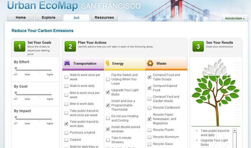
The web-based tool allows citizens to view their neighborhood’s statistics in regards to transportation, energy, and waste. Then, they are offered solutions that correspond to their priorities. For example, a person who chooses that they would like to make an impact in the cheapest way would get different suggestions than those who want to make the greatest impact possible. It will be interesting to see whether this form of education and resources will be more significant than other education campaigns. The inclination to pursue this kind of environmental project lies in the “seeing is believing” concept and the power of quantification. Most people, especially in San Francisco and Amsterdam, know that they should walk, bike, carpool, use public transportation, and purchase hybrids for personal use, but there is nothing to indicate whether their personal action has had an overall effect. Urban EcoMap lets you select combinations of actions to reach a reduction of 2 metric tonnes of CO2 and leaves it at that–this gives a reasonable target that people can reach with 5 or 6 behavior changes without becoming overwhelmed.

Urban_ecomap

Users are also given the power to share their choices via Facebook, making the city the starting point, but not ending point of support. The interconnectedness of the initiatives in the two cities (governmentally and through their corporate backing from Cisco) brings into question whether cities have more in common and more to benefit from each other than from their nation as a whole. Cities as similar as San Francisco and Amsterdam may be better suited to innovate in tandem than would say, San Francisco and Monterey. Proximity is no longer crucial; indeed, this is a goal of Connected Urban Development, and this international communication will surely become only more common with time. 


The City